 GeoDLL v.18.24
Advertisement
Description
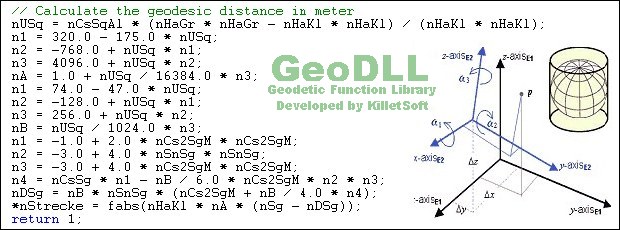
GeoDLL is a Geodetic Development Kit / Geodetic Function Library with worldwide 2D and 3D Coordinate Transformation, Datum Shift, Meridian Convergence and Extra Parameter with highest accuracy. Furthermore: Helmert and Molodensky Parameters, NTv2, HARN, INSPIRE, EPSG, Digital Elevation Model (DEM), distance and Time Zone calculations and much more. GeoDLL for geodetic and GIS development is available as 32Bit and 64Bit DLL and as C++ source...
Read more
- Rate:
- Release Date:09/29/2018
- License:Shareware
- Category:.NET Components
- Developer:Killet Software Ing.-GbR
- Downloads:822
- Size:5.1 Mb
- Price: $620.00
To free download a trial version of GeoDLL, click here
To buy software GeoDLL, click here
To visit developer homepage of GeoDLL, click here
Advertisement
Versions History
| Version | Date Released | Release Notes |
| 18.24 | 29.09.2018 | New NTv2 Reference Systems of Great Britain, Hungary and Venezuela. New function getntvgridarray() for arrays with NTv2 grid information. Updated time zone and daylight saving time data in GeoDLL. Insertion of Polygonal Validity Scopes into a NTV2 binary file. New tools for processing NTv2 files. |
| 18.16 | 06.08.2018 | Updated time zone and daylight saving time data in GeoDLL. Insertion of Polygonal Validity Scopes into a NTV2 binary file. New tools for processing NTv2 files. New CRS of Australia MGA2020 / GDA2020 with NTv2 support. New Coordinate System NAC-Code, (c) NAC Geographic Products Inc. |
| 17.28 | 08.08.2017 | Meridian Convergence, Origin Center Meridian, Geographical Point. All CRS of Taiwan. New NTv2 systems for German Federal States Baden-Württemberg and Bavaria. Automatic search for matching NTv2 files. New CRS GDA2020 und ITRS-Epochs of Australia. Support of Polygonal Validity Scopes in NTv2 files. |
| 17.11 | 16.03.2017 | New Reference System GDA2020 und ITRS-Epochs of Australia. ITRS epochs ITRF2008 of 2017 and 2018. NTv2 systems for Berlin, Bavaria and Mecklenburg. Digital signature for secure installation of the DLL. Forward and Backward Transformations. Support of Polygonal Validity Scopes in NTv2 files. |
| 17.17 | 14.01.2017 | New NTv2 systems for German Federal States Berlin, Bavaria and Mecklenburg. Digital signature for secure installation of the DLL. New CRS for Czechia, Slovakia, Albania, Cyprus and Switzerland. ITRS epochs of EUREF GPS Campaign ITRF2008. Support of Polygonal Validity Scopes in NTv2 files. |
| 16.32 | 05.11.2016 | New CRS of Berlin, Cyprus, Liechtenstein, Switzerland. New S-JTSK systems of Czechia and Slovakia. New CRS of South- and North-Korea and Mauritius. ITRS epochs of EUREF GPS Campaign ITRF2008. Implementation of Forward and Backward Transformations. Support of Polygonal Validity Scopes in NTv2 files. |
| 16.20 | 18.05.2016 | All CRS of South- and North-Korea added. Implemention of Forward and Backward Transformations. Support of Polygonal Validity Scopes in NTv2 grid files. 93 new Minnesota County coordinate systems. WINDOWS©10 certification and intensive test under WIN10. ITRS epochs of the EUREF GPS Campaign ITRF2008. |
| 16.19 | 21.04.2016 | Realisaton of Forward and Backward Transformations. Support of Polygonal Validity Scopes in NTv2 grid files. 93 new Minnesota County coordinate systems. WINDOWS©10 certification and intensive test under WIN10. ITRS epochs of the EUREF GPS Campaign ITRF2008. New functions to determine EPSG parameters |
| 16.09 | 25.01.2016 | Support of Polygonal Validity Scopes in NTv2 grid files. 93 new Minnesota County coordinate systems. WINDOWS©10 certification after intensive test. ITRS epochs of the EUREF GPS Campaign ITRF2008. French Lambert CC42 upto CC50 coordinates. New functions to determine EPSG parameters. |
| 15.21 | 04.10.2015 | WINDOWS©10 certification. ITRS epochs of the EUREF GPS Campaign ITRF2008. French Lambert CC42 upto CC50 coordinates. New functions to determine EPSG parameters. New functions with point to point calculation. Timezones from coordinates several mile territorial limits. |
| 15.18 | 25.07.2015 | New functions to determine EPSG parameters. New functions with point to point calculation from distance and bearing. Timezones from coordinates with inclusion of several mile territorial limits. All HARN/HPGN gridfile Reference Systems of the United States. Visual Studio C/C++ Test-Project. |
Screen Shot
Click on a thumbnail for the larger image.
System Requirements
GeoDLL requires Win2000, WinXP, Win7 x32, Win7 x64, Windows 8, Windows 10, WinServer, WinOther, Windows2000, Windows2003, Windows Server 2012, Windows Tablet PC Edition 2005, Windows Media Center Edition 2005, WinVista, Windows Vista Starter, Windows Vista Home Basic, Windows Vista Home Premium, Windows Vista Business, Windows Vista Enterprise, Windows Vista Ultimate, WinVista x64, Windows Vista Home Basic x64, Windows Vista Home Premium x64, Windows Vista Business x64, Windows Vista Enterprise x64, Windows Vista Ultimate x64.
GeoDLL v.18.24 Copyright
Shareware Junction periodically updates pricing and software information of GeoDLL v.18.24 full version from the publisher using pad file and submit from users. Software piracy is theft, Using crack, password, serial numbers, registration codes, key generators, cd key, hacks is illegal and prevent future development of GeoDLL v.18.24 Edition. Download links are directly from our publisher sites. Links GeoDLL v.18.24 from Bittorrent, mediafire.com, uploadfiles.com, hotfiles.com rapidshare.com, megaupload.com, netload.in, storage.to, depositfiles.com and other files hosting are not allowed. The download file is obtained directly from the publisher, not from any Peer to Peer file sharing applications such as Shareaza, Limewire, Kazaa, Imesh, eDonkey, eMule, Ares, BearShare, Overnet, Morpheus, BitTorrent Azureus and WinMX.
Review This Software
More GeoDLL Software
Advertisement

GeoDLL Deutsch v.14.60
GeoDLL supports the development of geodetic software on various platforms by providing geodetic functions. GeoDLL contains precise calculations on the themes 2D and 3D coordinate transformation, geodetic datum shift and reference system and more.
GeoDLL English v.14.60
GeoDLL supports the development of geodetic software on various platforms by providing geodetic functions. GeoDLL contains precise calculations on the themes 2D and 3D coordinate transformation, geodetic datum shift and reference system and more.

GeoDLL v.18.24
GeoDLL is a Geodetic Development Kit / Geodetic Function Library with worldwide 2D and 3D Coordinate Transformation, Datum Shift, Meridian Convergence and Extra Parameter with highest accuracy. Helmert, NTv2, HARN, INSPIRE, EPSG, DEM and much more
TOPOWIN v.16.00
TOPOWIN is a state-wide register of the German topographic cartographies and of localities with geo references in different coordinate systems. It also is a topographic information system.

SEVENPAR v.8.01
SEVENPAR calculaties exact parameter sets for the Spatial Helmert or Molodensky Transformation with seven or three parameters, which are used for accurate geodetic datum shifts between different reference systems for coordinate transformations.

TRANSDAT English v.17.75
TRANSDAT Coordinate Conversion supports thousands of coordinate systems and geodetic datum shifts, user-defined systems, INSPIRE, NTv2, BeTA2007, GPS, continental drift, Shape, KML, CSV and other file systems and much more with highest accuracy.

TRANSDAT Deutsch v.17.75
TRANSDAT Coordinate Conversion supports thousands of coordinate systems and geodetic datum shifts, user-defined systems, INSPIRE, NTv2, BeTA2007, GPS, continental drift, Shape, KML, CSV and other file systems and much more with highest accuracy.
Other products of this developer Killet Software Ing.-GbR

DRAGSENS v.4.01
DRAGSENS Geo Software is used for the exact posi... estimation of the position of a dragged sensor.

Geodata Germany v.22.03
The database contain geodata of the Federal Repu...capes, climatic zones for proximity searches ec.

Geodata International v.10.05
Geodata International - World-wide database of c...ximity search, navigation, distance calculation.

Graphics4VO DLL v.11.04
Graphics4VO is the graphics interface for the pr... the display, printer, plotter, file and memory.

ORTWIN v.13.02
ORTWIN is a program for the inquiry of localitie...capes, natural units, snow- and wind load zones.

SEVENPAR v.8.01
SEVENPAR calculaties exact parameter sets for th...eference systems for coordinate transformations.

TOPOWIN v.16.00
TOPOWIN is a state-wide register of the German t...ms. It also is a topographic information system.

TRANSDAT v.20.37
TRANSDAT Coordinate Conversion supports thousand...le systems and much more with highest accuracy.